Topographic illumination correction for Sentinel 2 - Python API
Published on Apr 26, 2020 | Bikesh Bade | 3234 Views
In mountain areas varying illumination conditions related to sun position, slope, and aspect result in variations of the reflectance within the same land cover type and e.g. the same forest type on a sunlit slope shows a different reflectance on a shaded slope. This signal-to-noise ratio can be reduced by performing a topographic illumination correction that adjusts differences in solar irradiance related to slope and aspect, resulting in an image that approximates reflectance values that would be recorded over a flat surface.
Different approaches exist for the topographic illumination correction and they can be grouped into three categories:
1) Empirical methods,
2) physical methods, and
3) semi-empirical methods.
We did not implement any of the empirical methods in the GEE image pre-processing tool as it can reduce accuracies. The two other approaches additionally use a digital elevation model (DEM) for the topographic correction of the images. Before correcting illumination in the image, first, we have to calculate the illumination condition. The following Function to calculate illumination condition is provided by Patrik Burns and Matt Macander.
𝐼𝐿 = 𝑐𝑜𝑠(𝑖𝑠 ) = 𝑐𝑜𝑠(𝑍) ⋅ 𝑐𝑜𝑠(𝑠) + 𝑠𝑖𝑛(𝑍) ⋅ 𝑠𝑖𝑛(𝑠) ⋅ 𝑐𝑜𝑠(𝑎 − 𝑎′)


Calculation of the illumination condition (IL) for each pixel at the time of the image acquisition using a DEM,
with
𝑖𝑠 = incident angle with respect to the surface normal
Z = solar zenith angle (incident angle for a horizontal surface, provided by the sensor metadata
s = terrain slope calculated from the DEM
a = solar azimuth (provided by the sensor metadata)
a’ = terrain aspect (azimuth) calculated from the DEM
To calculate the illumination condition in the GEE using python API first you have to setup python environment in your local computer.
Set up Python API for GEE and continue following
Step 1
The Python API package is called ee. It must also be initialized for every new session and script. and import other necessary modules
# import Google earth engine module
import ee

#Authenticate the Google earth engine with google account
ee.Initialize()

#python moduel for gee
import geetools

#python math module
import math
Step 2
Get Terrian Layer for DEM
# get terrain layers
dem = ee.Image("USGS/SRTMGL1_003")
Step 3
Create a Python function to calculate the illumination condition:
 # Function to calculate illumination condition (IC). Function by Patrick Burns
def illuminationCondition(img):

    # Extract image metadata about solar position
    SZ_rad = ee.Image.constant(ee.Number(img.get('MEAN_SOLAR_ZENITH_ANGLE'))).multiply(3.14159265359).divide(180).clip(img.geometry().buffer(10000))
    SA_rad = ee.Image.constant(ee.Number(img.get('MEAN_SOLAR_AZIMUTH_ANGLE')).multiply(3.14159265359).divide(180)).clip(img.geometry().buffer(10000))

    # Creat terrain layers
    slp = ee.Terrain.slope(dem).clip(img.geometry().buffer(10000))
    slp_rad = ee.Terrain.slope(dem).multiply(3.14159265359).divide(180).clip(img.geometry().buffer(10000))
    asp_rad = ee.Terrain.aspect(dem).multiply(3.14159265359).divide(180).clip(img.geometry().buffer(10000))

    # Calculate the Illumination Condition (IC)
    # slope part of the illumination condition
    cosZ = SZ_rad.cos()
    cosS = slp_rad.cos()
    slope_illumination = cosS.expression("cosZ * cosS",
                                          {'cosZ': cosZ,
                                           'cosS': cosS.select('slope')})


    # aspect part of the illumination condition
    sinZ = SZ_rad.sin()
    sinS = slp_rad.sin()
    cosAziDiff = (SA_rad.subtract(asp_rad)).cos()
    aspect_illumination = sinZ.expression("sinZ * sinS * cosAziDiff",
                                           {'sinZ': sinZ,
                                            'sinS': sinS,
                                            'cosAziDiff': cosAziDiff})

    # full illumination condition (IC)
    ic = slope_illumination.add(aspect_illumination)

    # Add IC to original image
    img_plus_ic = ee.Image(img.addBands(ic.rename('IC')).addBands(cosZ.rename('cosZ')).addBands(cosS.rename('cosS')).addBands(slp.rename('slope')))
    return img_plus_ic
The next step is to correct the illumination condition in the GEE using python is to create the function as follows:
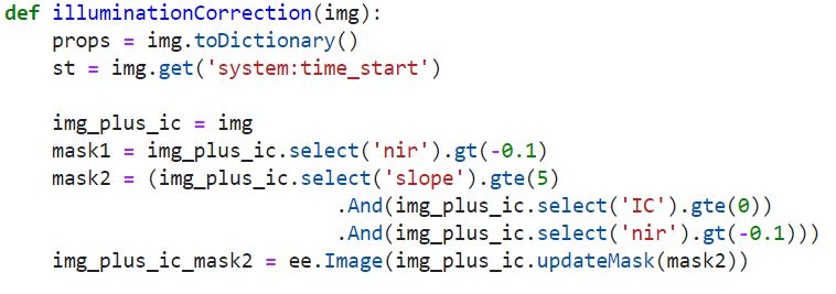
# Function to apply the Sun-Canopy-Sensor + C (SCSc) correction method to each
def illuminationCorrection(img):

    props = img.toDictionary()
    st = img.get('system:time_start')

    img_plus_ic = img
    mask1 = img_plus_ic.select('nir').gt(-0.1)
    mask2 = (img_plus_ic.select('slope').gte(5)
                            .And(img_plus_ic.select('IC').gte(0))
                            .And(img_plus_ic.select('nir').gt(-0.1)))
    img_plus_ic_mask2 = ee.Image(img_plus_ic.updateMask(mask2))

    # Specify Bands to topographically correct
    #bandList = ee.List(['blue','green','red','nir','swir1','swir2'])
    bandList = ['blue','green','red','nir','swir1','swir2']
    compositeBands = img.bandNames()
    nonCorrectBands = img.select(compositeBands.removeAll(bandList))

    geom = ee.Geometry(img.get('system:footprint')).bounds().buffer(10000)

    def apply_SCSccorr(band):
        method = 'SCSc'
        out =  (ee.Image(1).addBands(img_plus_ic_mask2.select('IC', band))
                            .reduceRegion(reducer= ee.Reducer.linearRegression(2,1),
                                           geometry= ee.Geometry(img.geometry()),
                                           scale= 300,
                                           bestEffort =True,
                                           maxPixels=10000000000))

        fit = out.combine({"coefficients": ee.Array([[1],[1]])}, False)

        #Get the coefficients as a nested list,
        # ast it to an array, and get just the selected column
        out_a = (ee.Array(fit.get('coefficients')).get([0,0]))
        out_b = (ee.Array(fit.get('coefficients')).get([1,0]))
        out_c = out_a.divide(out_b)

        # Apply the SCSc correction
        SCSc_output = img_plus_ic_mask2.expression(
        "((image * (cosB * cosZ + cvalue)) / (ic + cvalue))", {
        'image': img_plus_ic_mask2.select(band),
        'ic': img_plus_ic_mask2.select('IC'),
        'cosB': img_plus_ic_mask2.select('cosS'),
        'cosZ': img_plus_ic_mask2.select('cosZ'),
        'cvalue': out_c
        })

        return SCSc_output


    img_SCSccorr = ee.Image(list(map(apply_SCSccorr,bandList))).addBands(img_plus_ic.select('IC'))

    bandList_IC = ee.List([bandList, 'IC']).flatten()
    img_SCSccorr = img_SCSccorr.unmask(img_plus_ic.select(bandList_IC)).select(bandList)

    return img_SCSccorr.addBands(nonCorrectBands).setMulti(props).set('system:time_start',st)
The final step is to call the function:
def topoCorrection(collection):

    #call function to calculate illumination condition
    collection = collection.map(illuminationCondition)

    #call function to calculate illumination Correction
    collection = collection.map(illuminationCorrection)

    return(collection)


# Get Sentinel-2 data
s2s =(ee.ImageCollection('COPERNICUS/S2')
          .filterDate(startDate,endDate) # choose your date
          .filterBounds(studyArea) # choose your study area
          .filter(ee.Filter.lt('CLOUDY_PIXEL_PERCENTAGE',20))
          .filter(ee.Filter.lt('CLOUD_COVERAGE_ASSESSMENT',20)))

#call correcion function
s2 = topoCorrection(s2)
Responses

Iqbal
Excellent the code is working. I would like to ask. How to get the value of topograhic illumination?
- Feb 02, 2022 |
Admin
Based on different satellite and sensor there are different logic on topographic illumination corrections. you will need to go through the sensor / satellite documentation.
- Feb 08, 2022 |


